An attempt to travel along Omand's Creek
Omand’s Creek enters the City of Winnipeg from the RM of Rosser and flows southward through St. James Industrial park until it reaches the Assiniboine River. Although the creek passes through several city-owned parks, walking the length of Omand's Creek is difficult, sometimes dangerous, and often impossible.
 A rough sketch of Omand's Creek
Brookside Cemetery has multiple winding paths. Many of them are cement, and a few follow directly along the the creek. All of the paths are forested and there are many benches along the water, and picnic tables throughout the cemetery. A pedestrian bridge crosses over the creek on the East side of the cemetery. Signs are provided for navigation. A path follows along the creek as it exits the cemetery towards Notre Dame Ave. Flowing under Notre Dame Ave, the creek re-emerges in property owned by the Winnipeg Airport Authority. This portion of the Creek is narrow and faces the back lanes of warehouses. Debris, such as cinder blocks and gravel, is sliding into the Creek. As the creek turns west, it is blocked by another fence. Yet another fence crosses over the Creek as it flows under Sherwin Rd.
 Brookside Cemetery
The Creek continues along Dublin Ave. A small sliver of land (about 10 metres on each side of the Creek) is owned by the City of Winnipeg. Several culverts are built across the Creek to connect Dublin Ave to businesses on the other side. These culverts are very low and it was impossible to walk under them. Multiple train tracks cross the creek as well. Many of these tracks run on to property that is not used for industrial purposes. These tracks are likely not used; once they reach the other side of the creek, they are completely paved over. In some cases, the grass growing along the Creek has been mowed. Near the Peak of the Market warehouse at the intersection of Dublin and King Edward, gravel and large rocks are piled up to the edge of the water. Near the intersection of Border St and Dublin Ave, a small wedge - 1.26 hectares - of greenspace has been preserved. There are no paths along any of this segment.
 Paved-over railroad track
The Creek turns South and flows along McCrossen St. A good 20 metres of walking space is provided on the West side of the Creek. There is no formal path, but the trail is quite accessible due to repeated use. A barbed wire fence runs along the Creek; I could walk along the Creek, but could not access to the Creek itself. On the East side of the Creek is the abandoned Dominion Bridge factory, which is - according to the most recent online tax information - owned by the City of Winnipeg (City of Winnipeg, 2010). A deteriorating barrier, presumably built to prevent industrial debris from falling into the Creek, is rusting and debris is falling through. Large slabs of concrete are slowly falling into the water. Thus, the Creek itself is completely inaccessible on either side. The path stops near Saskatchewan Ave., and there is a picnic table (only Heaven knows why) at this cul-de-sac. A chain link fence prevents anyone from walking further southward; a railroad track crosses the Creek on the other side of the fence.
 Beside abandoned Dominion Bridge factory
After running under Saskatchewan Ave, Omand’s Creek flows along Empress St. To the West is a warehouse used by Safeway grocery stores. To the East is a road with no sidewalks. An old wooden fence runs along a small portion of the Creek; an old street sign lies in the tall grass. Further south, the Creek enters Westview Park, which is owned by the City of Winnipeg. There is no path along the Creek in this park, and still no sidewalk along Empress St. As Omand’s Creek crosses South under Wellington Avenue, it enters private property. The owner of this property, 4841035 Manitoba Ltd, has built a hideous parking lot directly over top of the Creek, making it completely impassible.
 Parking lot built over top of Creek
On the South side of Sargeant Avenue, there is a path that runs along the Creek. This path is built to allow pedestrian to cross over the culverts that cross over the Creek. The path is gravel and provides limestone benches nearby. However, the path runs very close to the blank wall of a Wal-Mart, which is rather imposing. This path (and the Creek) runs through private land. South of Ellice, the gravel path runs directly next to a large parking lot: there is no separation between the Creek and the concrete lot.
 Bluestem Nature Park
As the path crosses southward over St Matthews Ave, it enters Bluestem Nature Park, which is owned by the City of Winnipeg. Bluestem Park provides a nature buffer in between the commercial development and the gravel path. There are interpretive signs and a pedestrian bridge that crosses the Creek. At the end of Bluestem Park, the Creek flows under a train bridge that is still actively used. The gravel path does not continue under the bridge, but repeated wear from pedestrians has created a small path.
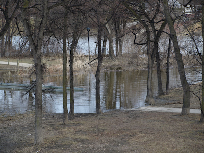 Omand Park bridge (flooded at the time)
Flowing southward under Portage Ave, Omand’s Creek enters Omand’s Park. While preserving much of the natural surroundings, Omand’s Park also provides benches, lit pathways, two baseball diamonds, and smaller walkways along the river. At the time of my visit, a pedestrian bridge that crosses over Omand’s Creek was impassible, as it was flooded by the Creek. Omand’s Creek continues through the park until it reaches the Assiniboine River.
If (for whatever reason) you want to read more about the Creek, you can download my somewhat longer report on the subject.
 A rough sketch of Omand's Creek
Earlier this year, I attempted to navigate the portion of Omand's Creek that lies within the City limits.
As Omand’s Creek enters Winnipeg, it flows through a city park simply called “Omand’s Creek 9”. Accessing the park off of the highway is difficult; I had to leap over a marshy area to reach solid ground. There is no walking trail through the park. Attempting to walk through the park brings visitors through a field of thistles. A waterfowl nest is installed in the creek and mallard ducks were spotted nearby. There is ample room for walking, especially on the west side of the park. The park is crossed by a bridge and continues until it reaches Brookside Cemetery. Although the park and the cemetery are both owned by the City of Winnipeg, a series of chain-link and barbed wire fences block visitors from walking from the park to the cemetery. Because I did not feel like walking through the Creek or ripping my clothing on the barbed wire, I opted to take the (very) long way around.
 Fence blocking access to cemetery
As Omand’s Creek enters Winnipeg, it flows through a city park simply called “Omand’s Creek 9”. Accessing the park off of the highway is difficult; I had to leap over a marshy area to reach solid ground. There is no walking trail through the park. Attempting to walk through the park brings visitors through a field of thistles. A waterfowl nest is installed in the creek and mallard ducks were spotted nearby. There is ample room for walking, especially on the west side of the park. The park is crossed by a bridge and continues until it reaches Brookside Cemetery. Although the park and the cemetery are both owned by the City of Winnipeg, a series of chain-link and barbed wire fences block visitors from walking from the park to the cemetery. Because I did not feel like walking through the Creek or ripping my clothing on the barbed wire, I opted to take the (very) long way around.
Fence blocking access to cemeteryBrookside CemeteryThe Creek continues along Dublin Ave. A small sliver of land (about 10 metres on each side of the Creek) is owned by the City of Winnipeg. Several culverts are built across the Creek to connect Dublin Ave to businesses on the other side. These culverts are very low and it was impossible to walk under them. Multiple train tracks cross the creek as well. Many of these tracks run on to property that is not used for industrial purposes. These tracks are likely not used; once they reach the other side of the creek, they are completely paved over. In some cases, the grass growing along the Creek has been mowed. Near the Peak of the Market warehouse at the intersection of Dublin and King Edward, gravel and large rocks are piled up to the edge of the water. Near the intersection of Border St and Dublin Ave, a small wedge - 1.26 hectares - of greenspace has been preserved. There are no paths along any of this segment.
Paved-over railroad trackThe Creek turns South and flows along McCrossen St. A good 20 metres of walking space is provided on the West side of the Creek. There is no formal path, but the trail is quite accessible due to repeated use. A barbed wire fence runs along the Creek; I could walk along the Creek, but could not access to the Creek itself. On the East side of the Creek is the abandoned Dominion Bridge factory, which is - according to the most recent online tax information - owned by the City of Winnipeg (City of Winnipeg, 2010). A deteriorating barrier, presumably built to prevent industrial debris from falling into the Creek, is rusting and debris is falling through. Large slabs of concrete are slowly falling into the water. Thus, the Creek itself is completely inaccessible on either side. The path stops near Saskatchewan Ave., and there is a picnic table (only Heaven knows why) at this cul-de-sac. A chain link fence prevents anyone from walking further southward; a railroad track crosses the Creek on the other side of the fence.
Beside abandoned Dominion Bridge factoryAfter running under Saskatchewan Ave, Omand’s Creek flows along Empress St. To the West is a warehouse used by Safeway grocery stores. To the East is a road with no sidewalks. An old wooden fence runs along a small portion of the Creek; an old street sign lies in the tall grass. Further south, the Creek enters Westview Park, which is owned by the City of Winnipeg. There is no path along the Creek in this park, and still no sidewalk along Empress St. As Omand’s Creek crosses South under Wellington Avenue, it enters private property. The owner of this property, 4841035 Manitoba Ltd, has built a hideous parking lot directly over top of the Creek, making it completely impassible.
Parking lot built over top of CreekOn the South side of Sargeant Avenue, there is a path that runs along the Creek. This path is built to allow pedestrian to cross over the culverts that cross over the Creek. The path is gravel and provides limestone benches nearby. However, the path runs very close to the blank wall of a Wal-Mart, which is rather imposing. This path (and the Creek) runs through private land. South of Ellice, the gravel path runs directly next to a large parking lot: there is no separation between the Creek and the concrete lot.
Bluestem Nature ParkAs the path crosses southward over St Matthews Ave, it enters Bluestem Nature Park, which is owned by the City of Winnipeg. Bluestem Park provides a nature buffer in between the commercial development and the gravel path. There are interpretive signs and a pedestrian bridge that crosses the Creek. At the end of Bluestem Park, the Creek flows under a train bridge that is still actively used. The gravel path does not continue under the bridge, but repeated wear from pedestrians has created a small path.
Omand Park bridge (flooded at the time)Flowing southward under Portage Ave, Omand’s Creek enters Omand’s Park. While preserving much of the natural surroundings, Omand’s Park also provides benches, lit pathways, two baseball diamonds, and smaller walkways along the river. At the time of my visit, a pedestrian bridge that crosses over Omand’s Creek was impassible, as it was flooded by the Creek. Omand’s Creek continues through the park until it reaches the Assiniboine River.
If (for whatever reason) you want to read more about the Creek, you can download my somewhat longer report on the subject.
Labels: greenspace, omand's creek, parks, winnipeg
posted by Gabriel Hurley @ 11:39 AM
![]()


2 Comments:
At 11:48 AM, Gregory Kohs said…
Gabriel, I would like to get your comment about "Big Cats" from Wikijunior, as I am writing a news article for Examiner.com.
Could you please contact me at ResearchBiz@gmail.com, since I don't readily see your e-mail contact info anywhere. Of course, you can then delete this "clutter" comment.
At 3:58 AM, Juliana G said…
It sounds like a challenging but interesting journey to explore Omand's Creek.
Post a Comment
<< Home